Учебное пособие по страноведению разработано для обучающихся техникумов. Пособие составлено с учетом максимального акцента на развитие устной речи, обучения переводу страноведческих текстов. Тексты содержат дополнительную информацию, направлены на расширение социокультурной эрудиции студентов.
Пособие состоит из четырёх уроков, каждый из которых включает текст для чтения и перевода, словарь, лексические и грамматические задания, направленные на отработку навыков устной речи и чтения.
Коми Республикаса йöзöс велöдан да том йöз политика министерство
Министерство образования, науки и молодёжной политики Республики Коми
Государственное профессионального образовательное учреждение
«Сыктывкарский торговотехнологический техникум»
УЧЕБНОЕ ПОСОБИЕ ПО СТРАНОВЕДЕНИЮ
«Интересное путешествие»
по дисциплине «Английский язык»
для профессий:
19.01.04 «Пекарь»
19.01.17 «Повар, кондитер»
38.01.02 «Продавец, контролёркассир»
Преподаватель английского языка
Высшая квалификационная категория
Мареева Людмила Викторовна
Сыктывкар2016
Учебное пособие по страноведению для профессий:
19.01.04 «Пекарь»
19.01.17 «Повар, кондитер»
38.01.02 «Продавец, контролёркассир»
– Сыктывкар , ГПОУ «СТТТ» 2016. – 18с.
Учебное пособие предназначено для студентов профессий
19.01.04 «Пекарь»
19.01.17 «Повар, кондитер»
38.01.02 «Продавец, контролёркассир»
изучающих английский язык с целью формирования коммуникативной и
социокультурной компетенции.
Система лексических и речевых упражнений, учебные тексты, создают
возможности для получения дополнительных знаний по страноведению и выработки
навыков просмотрового, поискового чтения и устной речи.
Составитель: Л.В. Мареева преподаватель ГПОУ «СТТТ»Содержание
Введение……………………………………………………….……………..4
Lesson №1. The United Kingdom of Great Britain and Northern
Ireland………………………………………………….
5
Lesson №2. The United States of America
……………………………………………………… 7Lesson №3. Russian Federation …………………………………………… 8
Lesson №4. The Republic of Komi ……………………………………………10
Рекомендуемая литература ………………………………………………… 17Введение
Учебное пособие «The interesting travel» разработано для студентов профессий
19.01.04 «Пекарь»
19.01.17 «Повар, кондитер»
38.01.02 «Продавец, контролёркассир»
Цель данного пособия: формирование коммуникативной и социокультурной
компетенции, Изучение языка и культуры одновременно, обеспечивает не только
эффективное достижение практических, общеобразовательных и развивающих целей,
но и содержит значительные возможности для вызова и дальнейшего поддержания
мотивации обучаемых.
Пособие составлено с учетом максимального акцента на развитие устной речи,
обучения переводу страноведческих текстов. Тексты содержат дополнительную
информацию, направлены на расширение социокультурной эрудиции студентов.
Пособие состоит из четырёх уроков, каждый из которых включает текст для
чтения и перевода, словарь, лексические и грамматические задания, направленные на
отработку навыков устной речи и чтения.Lesson №1
Theme: The United Kingdom of Great Britain and Northern Ireland
The United Kingdom of Great Britain and Northern Ireland consists of four formerly
independent countries. They are England, Scotland, Wales and Northern Ireland. The
capital of Scotland is Edinburgh, the capital of Wales is Cardiff, the capital of Northern
Ireland is Belfast and the capital of England is London. The country is surrounded by seas
on all sides and is separated from the continent by the English Channel and the Strait of
Dover. The British Isles consist of more than 5,000 small islands. The biggest of them is
Great Britain. The geographical position favoured the development of the United Kingdom
as a great sea country. It's famous for great geographical discoveries and glorious victories
of the British fleet.
The country occupies an area of over 244,000 sq km. It is a densely populated country. The
population is about 58 million people. About 80 per cent of the population live in town.
The scenery and the landscape of Great Britain are very diverse. There you can find flat
valleys and high land, forests and lake areas. The highest mountain peaks are Ben Nevis in
Scotland and Snowdon in Wales. The rivers in Great Britain are not long. The Thames is
the most important waterway in the country, though the longest river is the Severn. The
Mersy is another long river which once played an important role in British trade and
commerce.
As for the climate of Great Britain, it is moderate and mild due to the influence of the warm
waters of the Gulf Stream. The summers are usually cooler than on the continent. There is a
lot of rain in autumn and winter. The weather in Britain is very changeable and the English
even say they have no climate but only weather, which through centuries has become a
favourite topic of conversation with the British.
English is not the only language, which people use in the UK. English is the official
language, but some people speak Gaelic in western Scotland, Welsh – in parts of northern
and central Wales.
Foreigners usually call the British people «English», but the Scots, the Irish and the Welsh
do not consider themselves to be English. The English are AngloSaxon in origin, but the
Welsh, the Scots and the Irish are not. They are Celts; descendants of the ancient people
who crossed over from Europe to the British Isles centuries before the Roman invasion. It
was these people whom the Germanic Angles and Saxons conquered in the 5th and 6th
centuries A.D.
The flag of the UK, known as the Union Jack, is made up of three crosses on a blue ground.
The blue colour refers to the seas surrounding Britain. The upright red cross is the cross of
St. George, the patron saint of England. The white diagonal cross is the cross of St.
Andrew, the patron saint of Scotland. The red diagonal cross is the cross of St. Patrick, the
patron saint of Ireland.
The United Kingdom is a highly developed industrial state. Historically British industry
started chiefly as heavy and textile industry. There are hardly any coal mines in Britain
today, but textile industry is still prospering. The United Kingdom produces and exportsiron and steel products, machinery and electronics. The biggest industrial centres are
London, Glasgow, Liverpool, Sheffield, Birmingham and Manchester.
The British say that they grow most of the food they consume, but of course, some of the
food like coffee, tea, fruit and wine is imported. The chief agricultural crops are wheat,
barley, oats, potatoes and fodder grasses.
The UK is a prosperous state with high living standards. But today Britain is no longer the
leading industrial nation in the world, which it used to be in the 19th century. A pioneer of
the Industrial Revolution, the former «world workshop» of the 19th century, Britain today
retains a respectable place among the most advanced countries of the world. She is the fifth
in terms of the size of the GDP (gross domestic product). Being a member of the European
Union (EU), more than a half of all Britain’s trade is maintained with the other comember
states. The second place in Britain’s foreign trade is taken by the USA, the Commonwealth
countries come third. Britain has an open economy, in which international trade plays a
vital role in the life of the country.
1 Complete the sentences using the information from the text.
1 The main countries of the UK are …
2 From the European continent the British Isles are separated by …
3 The advantages of the geographical position of Great Britain favoured…
4 The UK is famous for …
5 Great Britain is a country of great diversity because…
6 The climate of Great Britain is generally mind and temperate because…
7 The official language of the UK is English but…
8 If is difficult to find a typical Briton because…
9 The flag of the United Kingdom is made up of…
10 Britain has made important advances in such industries as …
11 The biggest industrial centres are…
12 British agriculture is efficient because…
13 The UK is a prosperous state with …
14 A pioneer of the Industrial Revolution Britain today retains…
15 Britain has an open economy, in which…
3 Fill in the blanks with the correct words from the text.
1 The United Kingdom of Great Britain and Northern Ireland consist of four … countries.
2 … is the capital of Northern Ireland.
3 The country is … by seas on all sides.
4 The biggest of the British Isles is …
5 Britain is famous for glorious victories of the …
6 The highest mountain peaks are … in Scotland and … in Wales.
7 The Thames is the most important … in the country.
8 The longest river is …
9 The climate of Great Britain is in fluenced by the warm waters of the …
10 The weather in Britain is very …11 The Welsh , the Scots and the Irish are … in origin.
12 The upright red cross is the cross of … , the patron saint of …
13 The UK produces and exports … and … products.
14 The UK is the fifth in terms of the size of …
15 Britain is a member of the …
16 The third place in Britain’s foreign trade is taken by the …
17 International trade plays a … in the life of the UK
4 Are the statements true or false? Correct the false statements.
1 The United Kingdom of Great Britain and Northern Ireland is situated on the British
Isles.
2 Northern Ireland is situated in the southern part of Ireland.
3 The UK is twice lager than France or Spain.
4 London is situated on the Thames which is the busiest waterway in the country.
5 Scotland is the nearest part to the European continent.
6 English is the only language spoken in the UK.
7 The English are Celts in origin.
8 Britain is still one of the leading industrial and trading countries in the world.
9 The British grow wheat, barley, oats, potatoes and fodder grasses.
10 Rainfall is fairly well distributed throughout the year.
11 Living standards are rather high in Great Britain.
12 The flag of the UK is made up of stars and stripes.
5. Read and translate:
LONDON
London is not only the capital of the most important Englishspeaking country.
It’s also one of the largest and most beautiful cities in the world.
The population of London at the moment is more than 8 million people.
Besides, London is inhabited by people of almost all nationalities and races.
The city lies on both banks of river Thames.
The most important parts of London are: the City, the East End, the West end and Westminster.
The busiest part is, of course, the City.
Thousands of companies, business organizations, banks and offices are situated there and
millions of people work there on daily basis.
The West End and the East End classification shows that London has still class distinction system.
The West End is traditionally inhabited by rich and successful people.
Besides, almost all the city theaters, museums, galleries, posh shops and restaurants
are situated in West End area.
East End is the place where working class lives.
This district is not as rich as others and has fewer parks.
Westminster area contains many sightseeing buildings.
The most famous of all is the Westminster Abbey.
It’s the place where many prominent Englishmen are buried.
Among them Charles Darwin, Isaac Newton, Alfred Tennyson and many others.London is full of places of interest.
When tourists arrive there, they want to see the Piccadilly Street, which is especially beautiful at night,
the Baker Street, the place where Sherlock Holmes lived and worked.
The Tower, which is famous as home of the Crown Jewels, the Hyde Park with its Speaker’s Corner,
the Museum of Madame Tussauds and many others.
One of the favourite tourist attractions is London Eye.
It’s one of the largest Ferris wheels in the world.
6. Read the first part of the sentence in A and find the second part in B.
A B
1.London is one of the
a. the City, the East End, the West End and
Westminster
2. The most important parts of London are:
b .where working class lives
3. The Piccadilly Street
4. The Westminster Abbey.
c. is London Eye
d. most beautiful cities in the world.
5. The Baker Street
e. where many prominent Englishmen are buried.
6. One of the favourite tourist attractions
f. is the place where Sherlock Holmes lived and
worked.
7. East End is the place
g. especially beautiful at night,
TEST «THE UK»
1. How many parts are there in the United Kingdom of Great Britain and Northern Ireland?
a three
b two
c)four
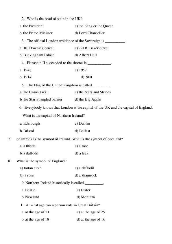
d) five2. Who is the head of state in the UK?
a the President
b the Prime Minister
c) the King or the Queen
d) Lord Chancellor
3. The official London residence of the Sovereign is __________.
a 10, Downing Street
b Buckingham Palace
с) 221B, Baker Street
d) Albert Hall
4. Elizabeth II succeeded to the throne in ____________.
a 1948
b 1914 d)1900
c) 1952
5. The Flag of the United Kingdom is called __________.
a the Union Jack
b the Star Spangled banner
c) the Stars and Stripes
d) the Big Apple
6. Everybody knows that London is the capital of the UK and the capital of England.
What is the capital of Northern Ireland?
a Edinburgh
b Bristol
c) Dublin
d) Belfast
7.
Shamrock is the symbol of Ireland. What is the symbol of Scotland?
a a thistle
b a daffodil
8. What is the symbol of England?
a) tartan cloth
b) a rose
c) a rose
d) a leek
c) a daffodil
d) a shamrock
9. Northern Ireland historically is called ___________.
a Beatle
b Newland
c) Ulster
d) Montana
1. At what age can a person vote in Great Britain?
a at the age of 21
c) at the age of 25
b at the age of 18
d) at the age of 162.
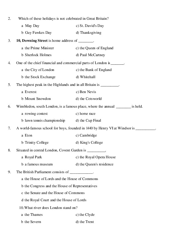
Which of these holidays is not celebrated in Great Britain?
a May Day
b Guy Fawkes Day
c) St. David's Day
d) Thanksgiving
3.
10, Downing Street is home address of _________.
a the Prime Minister
b Sherlock Holmes
c) the Queen of England
d) Paul McCartney
4.
One of the chief financial and commercial parts of London is ________.
a the City of London
b the Stock Exchange
c) the Bank of England
d) Whitehall
5.
The highest peak in the Highlands and in all Britain is ___________.
a Everest
b Mount Snowdon
c) Ben Nevis
d) the Cotsworld
6. Wimbledon, south London, is a famous place, where the annual _________ is held.
a rowing contest
c) horse race
b lawn tennis championship
d) the Cup Final
7.
A worldfamous school for boys, founded in 1440 by Henry VI at Windsor is ____________.
a Eton
b Trinity College
c) Cambridge
d) King's College
8.
Situated in central London, Covent Garden is ___________.
a Royal Park
b a famous museum
c) the Royal Opera House
d) the Queen's residence
9.
The British Parliament consists of ____________.
a the House of Lords and the House of Commons
b the Congress and the House of Representatives
c the Senate and the House of Commons
d the Royal Court and the House of Lords
10.What river does London stand on?
a the Thames
c) the Clyde
b the Severn
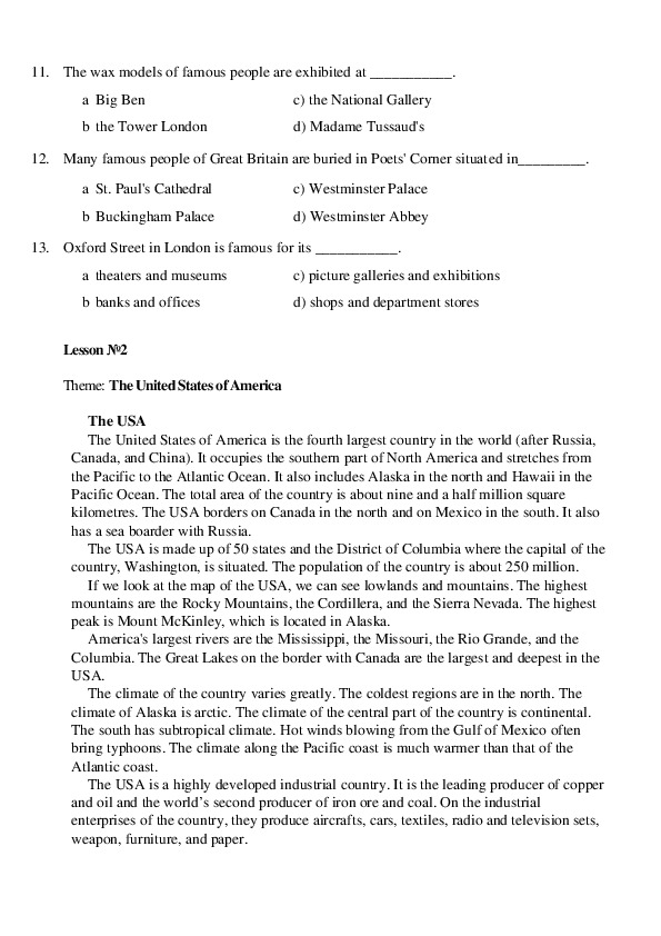
d) the Trent11. The wax models of famous people are exhibited at ___________.
a Big Ben
b the Tower London
c) the National Gallery
d) Madame Tussaud's
12. Many famous people of Great Britain are buried in Poets' Corner situated in_________.
a St. Paul's Cathedral
c) Westminster Palace
b Buckingham Palace
d) Westminster Abbey
13. Oxford Street in London is famous for its ___________.
a theaters and museums
c) picture galleries and exhibitions
b banks and offices
d) shops and department stores
Lesson №2
Theme: The United States of America
The USA
The United States of America is the fourth largest country in the world (after Russia,
Canada, and China). It occupies the southern part of North America and stretches from
the Pacific to the Atlantic Ocean. It also includes Alaska in the north and Hawaii in the
Pacific Ocean. The total area of the country is about nine and a half million square
kilometres. The USA borders on Canada in the north and on Mexico in the south. It also
has a sea boarder with Russia.
The USA is made up of 50 states and the District of Columbia where the capital of the
country, Washington, is situated. The population of the country is about 250 million.
If we look at the map of the USA, we can see lowlands and mountains. The highest
mountains are the Rocky Mountains, the Cordillera, and the Sierra Nevada. The highest
peak is Mount McKinley, which is located in Alaska.
America's largest rivers are the Mississippi, the Missouri, the Rio Grande, and the
Columbia. The Great Lakes on the border with Canada are the largest and deepest in the
USA.
The climate of the country varies greatly. The coldest regions are in the north. The
climate of Alaska is arctic. The climate of the central part of the country is continental.
The south has subtropical climate. Hot winds blowing from the Gulf of Mexico often
bring typhoons. The climate along the Pacific coast is much warmer than that of the
Atlantic coast.
The USA is a highly developed industrial country. It is the leading producer of copper
and oil and the world’s second producer of iron ore and coal. On the industrial
enterprises of the country, they produce aircrafts, cars, textiles, radio and television sets,
weapon, furniture, and paper.Though mainly European and African in origin, the Americans are made up from
nearly all races and nations, including the Chinese and the native Americans — Indians.
The largest cities are New York, Los Angeles, Chicago, Philadelphia, Detroit, San
Francisco, and others.
The United States is a federal republic consisting of 50 states, each of which has its
own government. The seat of the central (federal) government is Washington, D. C.
According to the Constitution of the USA, the powers of the government are divided
into 3 branches: the executive, headed by the President, the legislative, exercised by the
Congress, and the juridical. The Congress consists of the Senate and the House of
Representatives. There are two main political parties in the USA: the Republican and the
Democratic.
Task 1. Fill in the table using the text
The United States of America
№ The descriptions of the countries
1
2
It is situated on…
It is washed by…,
(oceans, seas)
It borders with…(countries)
The capital of the country is…
The climate of the country is…
Its territory is about…
The population is about…
The main political parties are…
The political system of the country
is…
3
4
5
6
7
8
9
10 The longest and the deepest rivers
are…
11 The biggest lakes are…
12 The mountains are…
13 The main resources are…
14 The main industries are…
15 The largest cities are…
16 The most famous sightseeing’s
are…
17 The total area of the country is…
Task 2: Read
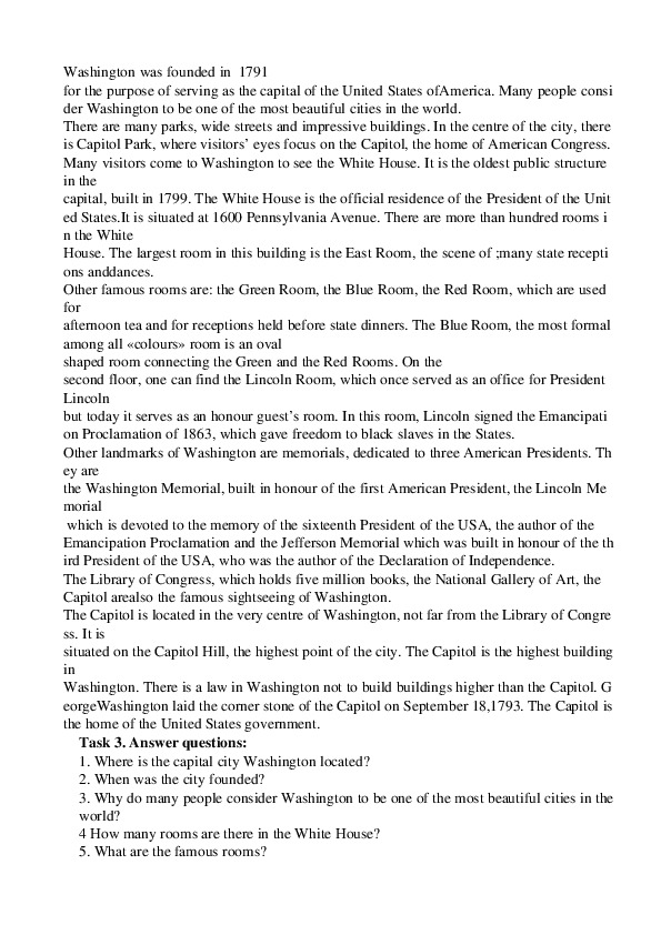
Washington, D.C.
Washington is the capital of
the United States of America. It is located in the District of Columbia. The district is name
d in honour of Columbus, the discoverer of America.Washington was founded in 1791
for the purpose of serving as the capital of the United States ofAmerica. Many people consi
der Washington to be one of the most beautiful cities in the world.
There are many parks, wide streets and impressive buildings. In the centre of the city, there
is Capitol Park, where visitors’ eyes focus on the Capitol, the home of American Congress.
Many visitors come to Washington to see the White House. It is the oldest public structure
in the
capital, built in 1799. The White House is the official residence of the President of the Unit
ed States.It is situated at 1600 Pennsylvania Avenue. There are more than hundred rooms i
n the White
House. The largest room in this building is the East Room, the scene of ;many state recepti
ons anddances.
Other famous rooms are: the Green Room, the Blue Room, the Red Room, which are used
for
afternoon tea and for receptions held before state dinners. The Blue Room, the most formal
among all «colours» room is an oval
shaped room connecting the Green and the Red Rooms. On the
second floor, one can find the Lincoln Room, which once served as an office for President
Lincoln
but today it serves as an honour guest’s room. In this room, Lincoln signed the Emancipati
on Proclamation of 1863, which gave freedom to black slaves in the States.
Other landmarks of Washington are memorials, dedicated to three American Presidents. Th
ey are
the Washington Memorial, built in honour of the first American President, the Lincoln Me
morial
which is devoted to the memory of the sixteenth President of the USA, the author of the
Emancipation Proclamation and the Jefferson Memorial which was built in honour of the th
ird President of the USA, who was the author of the Declaration of Independence.
The Library of Congress, which holds five million books, the National Gallery of Art, the
Capitol arealso the famous sightseeing of Washington.
The Capitol is located in the very centre of Washington, not far from the Library of Congre
ss. It is
situated on the Capitol Hill, the highest point of the city. The Capitol is the highest building
in
Washington. There is a law in Washington not to build buildings higher than the Capitol. G
eorgeWashington laid the corner stone of the Capitol on September 18,1793. The Capitol is
the home of the United States government.
Task 3. Answer questions:
1. Where is the capital city Washington located?
2. When was the city founded?
3. Why do many people consider Washington to be one of the most beautiful cities in the
world?
4 How many rooms are there in the White House?
5. What are the famous rooms?6. What can one find on the second floor?
7. Who is the Washington Memorial devoted to?
8. Why was the Jefferson Memorial built?
9. Where is the Capitol situated?
10. Who laid the corner stone of the Capitol?
11. How many books are there in the Library of Congress?
12. What was the document that gave freedom to black slaves in the States?
13. What building is the official residence of the President of the United States?
Vocabulary:
the Pacific — Тихий океан
northwest — северозападный
capital — столица
district — район; округ; область (как административная единица)
discoverer — первооткрыватель (of — чегол.); исследователь, первопроходец
to be located — быть расположенным
in honour of — в честь
to found — основать
the Capitol — здание конгресса США, Капитолий
to consider — считать, полагать
impressive — впечатляющий
scene — место действия, сцена
receptions — приемы
state reception — государственный прием
to sign — подписывать(ся), ставить подпись
emancipation — освобождение, высвобождение, раскрепощение; эмансипация (from);
свобода, избавление (от чегол. нежелательного, стесняющего)
proclamation — декларация; провозглашение, объявление, обнародование; воззвание,
прокламация
freedom — независимость, самостоятельность, свобода; политическое право*
политическая свобода
Declaration of Independence — Декларация независимости
slave — раб
to devote — посвящать
sightseeing — достопримечательности
government — правительство
Read the text and do some exercises to it.
From The History Of New York.
At the beginning of the 17th century only the wigwams of the Iroquois stood where
the skyscrapers of New York now reach to the clouds. In 1605 the first Europeans
came to Manhattan from Holland. Capitan Henry Hudson, searching for the famous
Northwest Passage, discovered the land and reached a river to which he gave his
name. In 1626 the Dutch Governor, Peter Minuit, concluded with them whatAmerican business experts call «the most profitable commercial deal in the U.S.
history». With several bottles of gin and
a handful of trinkets that cost twentyfour dollars, he bought a large island from the
simplehearted, trusting Indians. Later the Indians named the island Manhatta
(presentday Manhattan, the main borough of New York, which in Iroquois means:
«They cheated us».
It seems that at the dawn of private enterprise, too, it was hard to understand the
difference between «a commercial deal» and cheating, between «a miracle of
enterprise» and robbery.
The Dutch founded a city there and gave it the name «New Amsterdam».
After the English had taken over the city in 1626 it was renamed New York after
the Duke of York who was the commander of the English army.
During the War of Independence New York was an important political centre, and for
five years from 1785 till 1790, the capital of the USA.
Since the end of the 19th century the city began to develop at breakneck speed. In
1888 the first skyscraper was put up. It had only 13 storeys, but the next had twenty
two and so on. Situated at the mouth of the Hudson River, which is open to ocean
going ships the year round, New York quickly became one of the largest ports in the
world.
At the turn of the twentieth century, millions of people driven by poverty emigrated to
the United States from various countries of Europe. They entered the New World
through New York, the «Gateway of America.» New York attracts people from all
over the world. That is what makes people call it the «Modern Babylon.»
Now New York is the biggest city in the USA and one of the largest cities of the
World. The population of this city is near 12 million people. It is the capital of New
York State.
There are 5 boroughs in New York — Manhattan, Brooklyn, Queens, the Bronx, and
Staten Island or Richmond. Today New York City is informally called «The Big
Apple». Some call New York a poem in stone and steel, others a soulless monster, but
It is unlike any other city in the world.
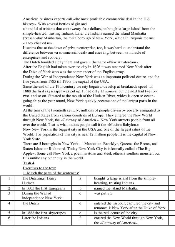
Task 4
Exercises to the text:
:
1. Match the parts of the sentences
The Dutchman Henry
Hudson
In 1605 the first Europeans
During the War of
Independence New York
The Dutch
bought a large island from the simple
hearting, trusting Indians.
named the island Manhatta.
was put up.
a
b
c
d
In 1888 the first skyscrapes
Later the Indians
e
f
entered the harbour, captured the city and
renamed it New York after the Duke of York.
is the real centre of the city.
entered the New World through New York,
the «Gateway of America».
1
2
3
4
5
67
8
9
1
0
1
1
1
2
1
3
1
4
1
5
1
6
1
7
1
8
1
9
2
0
In 1626 the Dutch Governer,
Peter Minuit,
Forty years later the English
fleet
At the turn of the twentieth
century millions of people
from various countries of
Europe
Manhattan, the smallest
island in New York
The most important branches
of industry
Broadway and Fifth Avenue
i
g
h
j
k
l
All districts of new York
m
The streets and highways of
New York
Fifth Avenue
New York, one of the USA
leading manufacturing cities
Broadway
The origin of the name «The
Big Apple»
The mouth of the Hudson
River
Since the end of the
19th century New York
n
o
p
q
r
s
t
discovered the land and reached a river to
which he gave his name.
came to Manhattan from Holland.
founded a city there and gave it the name
«New Amsterdam».
was an important political centre.
are linked together by numerous bridges.
are full or cars and buses.
are those producing vehiсles , glass,
chemicals and all kinds of machinery.
are the worldfamous streets in New York.
is unknown, but it is popular all over the
world.
is open to oceangoing ships the year round.
is the great shopping, hotel and club avenue.
began to develop at breakneck speed.
is the home of great firms and banks.
is the centre of the theatres and night life.
5
Task
4.Translate into English:
1). В начале ХVII века на месте небоскребов стояли лишь вигвамы ирокезов.
2). Остров Манхэттэн, деловой и финансовый центр НьюЙорка, был куплен
голландцами в 1626 году за горсть побрякушек.
3). Река Гудзон получила свое название благодаря голландцу Генриху Гудзону,
который ее обнаружил.
4). Голландцы основали город и назвали его «Новый Амстердам».
5). Позже город был захвачен англичанами и переименован в НьюЙорк.
6). На рубеже ХХ века люди из разных стран въезжали в США через НьюЙорк,
«ворота Америки».7). НьюЙорк называют «современным Вавилоном», т.к. там живут люди разных
национальностей.
8). Так как НьюЙорк расположен на островах (исключая Бронкс), все его части
соединены многочисленными мостами.
9). Основные отрасли промышленности НьюЙорка, одного из ведущих
промышленных городов мира, производство изделий из бумаги, машин,
химической продукции, станков.
10). НьюЙорк часто называют культурной столицей США, т.к. здесь много
музеев, картинных галерей, театров.
Task 6:
Fill in the blanks
with the correct words from the text:
1. There is a __________ in the base of the statue devoted to the history of immigration
to the USA.
2. Manhattan is __________ into Downtown, Midtown and Uptown regions.
3. Manhattan is crossed from north to south by avenues and from east to west by
__________.
4. In the old days the Dutch built there a strong wooden _________ to protect
themselves from the Indians.
5. The first building __________for skyscrapers came in the late 1920’s.
6. There are two observation platforms in the building, which are __________seven
days and nights a week.
7. The Empire State Building has become a _________ of New York.
8. The first skyscrapers were built in __________style.
9. Greenwich Village is mostly a ________ area.
10. Times Square got its name from the «new York Times» which has its main
________ there.
11. You can see the _________ plays, musicals and shows on Broadway.
12. The main headquarters of ________________ are situated in Midtown of
Manhattan.
13. After Central Park was opened some wealthy New Yorkers soon built ________
along Fifth Avenue.
14. The Guggenheim Museum has one of the world’s finest collections of modern and
________art.
Task 7:
№
1
2
3
4
5
Are these statements true or false?
Statements
A. Lincoln was born in Indianna.
His family was often on the move.
When he was a boy of nine, his mother died.
His father was a military man.
After his wife’s death, Lincoln’s father married again.6
7
8
9
10
11
12
13
14
Lincoln’s new mother didn’t take care of him.
When he was a child, he wanted to be a farmer.
Lincoln’s new mother encouraged him to reading.
The battle of Gettysburg was the decisive battle of the Civil war.
On July 3, 1863 the Confederates were forced to retreat by the
general George Meade.
The Declaration of Independence was adopted only 80 years ago
after the battle of Gettysburg.
The casualty on both sides were very heavy: more than 43000 men.
Lincoln wanted to go and talk to General Lee.
In his Gettysburg speech Lincoln said that «government of the
people, by the people and for the people shall not perish from the
earth».
TEST «The United States of America»
1.When did Christopher Columbus discover America?
a) 1402.
b) 1482.
c) 1492.
2. What part of America did Christopher Columbus discover?
a) Central America.
b) South America.
c) North America.
3. How is the flag of the USA called?
a) "Union Jack.
b) 'The Stars and Stripes".
c) "Stripes".
4. Who was the first president of USA?
a) George Washington.
b) Bill Clinton.
c) Abraham Lincoln.
5. What holiday do Americans celebrate on the 4th of July?
a) Flag Day.
b) Independence Day.
c) St. Patrick's Day.
6. Name the English ship, which brought the first English people to America.a) "Plymouth".
b) "Mayflower".
c) "New World".
7. What American place of interest is known to many children of the world?
a) The White House.
b) Tower of London.
c) Disneyland.
8. On what holiday do children say: "Trick or Treat! Money or eat!"?
a) Christmas.
b) Thanksgiving Day.
c) Halloween.
9. What is America's symbol of Freedom?
a) The Statue of Liberty.
b) The Bald Eagle.
c) The American Flag
10. What is the national symbol of America?
a) The White House.
b) The American Flag.
c) The Bald Eagle.
11. Who was the "king" of rock'n'roll?
a) Elvis Presley.
b) Margaret Mitchell.
c) M. Jackson.
12. Where are laws made in the USA?
a) in the White House.
b) in The Library of Congress.
c) in the Capitol.
13. How many senators are there in the Senate?
a) 50.
b) 100.
c) 150.
14. Who is the chairperson in the House of Representatives?
a) The Speaker.
b) The President.
c) The Senator.15. Who is the head of the state and the government of the USA?
a) The Congress.
b) The Senate.
c) The President.
16. What is America's national sport?
a) Football.
b) Baseball.
c) Golf.
17. Whose portraits are printed on American dollars?
a) The portraits of American presidents.
b) The famous actors.
c) The famous singers.
18. Who is the chairperson in the Senate?
a) The President.
b) The Senator.
c) The Vice President of the USA.
19. How many years did the War of Independence last?
a) 8 years.
b) 4 years.
c) 12 years.
20. How many years did the Civil War last in the USA?
a) 8.
b) 7.
c) 4.
21. Who wrote a large part of the Declaration of Independence?
a) Thomas Jefferson.
b) Christopher Columbus.
c) John Kennedy.
22. Name the first President who lived in the White House.
a) Gorge Washington.
b) John Adams.
c) John Kennedy.
23. What is the largest state in the USA?
a) Texas.b) Alaska.
c) Columbia.
24. What is the highest building in Washington D.C.?
a) The Capitol.
b) The White House.
c) The skyscrapers.
25. When do Americans celebrate Thanksgiving Day?
a) On the 17th of March.
b) On the 31st of October.
c) On the 3d Thursday of November.
Lesson 3
Theme: Russian Federation
Task 1. Read and translate
Russia is the largest countries in the world. It occupies about oneseventh part
of dry land. It is situated in Europe and in Asia. It`s total area is over 17 million square
kilometers, with population of 200 million people. There are 1,030 towns
and cities in this country. Moscow, with 9,5 million people, is it`s capital. The
country is washed by seas and oceans. By Arctic Ocean in the north and the
Pacific Ocean in the east. There are many rivers in Russia. The largest rivers
are the Volga in Europe and the Yenisei and OB in Asia. The deepest lakes are
the Baikal and
Ladoga. All rivers flow in the seas. The relief of Russia is mostly flat. Russia is located on t
wo plains the Great Russia Plain and the Western Siberian Plain. There are three main
mountains chains in
Russia. The Caucasus is a range of mountains which extend from the Black
Sea to the Caspian Sea. The highest mountain is the Caucasus. The highest
mountain in Caucasus in Russian Federation and in the whole Europe Mount
Elbrus is. The Urals extend from the Arctic Ocean to the steppes. This mountain
chain divides the European and Asian parts of Russia. The Urals are famous for
their valuable minerals. There are 150 volcanoes in Kamchatka, 30 of which are
active. Russia Federation is very rich in minerals resources, such as oil, natural gas, coal, ir
on , gold and others.
Russia borders on fourteen countries including the former republics of the USSR, which
are now independent states. Russia borders with Estonia, Latvia, Finland, Poland, China, M
ongolia, Korea, Japan, Kazakhstan and so on. Today Russia is one of the world`s largest
grain products and exporters. It produced 78 % of all its natural gas, 60 % of steel,80
% of timber and 91 % of oil. So, today Russia becomes greatestindustrial country. The main cities of Russia are: Moscow, St. Petersburg, Krasnoyarsk, Uf
a, Perm, Rostov — on — Don, Vladivostok. Many villages in
Russia are famous for their specific crafts: painted boxes in Palkn, Woodentableware in Kh
okhloma, and toys in Dymkovo. Moscow is the capital of Russia. It is one of the
biggest and most beautiful cities in the world. Moscow is the modern city. It`s the political
center, here the government of our country work.
Task 2 Answer the following questions:
1. Where is Russian Federation situated?
2. What is the total area of the country?
3. What countries does Russia border on?
4. What mountain chains do separate Europe from Asia?
5. How many rivers are there in Russia?
6. Which is the longest river in Europe?
7. What mineral resources are in Russia?
8. What are the main cities of Russia?
9. What is the capital of Russia?
10.
What great Russians do you know?
Task 3. Match the words with their explanations:
a.
b.
c.
lower house
the head of state
the Parliament of the Russian
Federation
1.
the State Duma
2. United Russia
3. a bill
d. a written proposal for a new law,
4.
the President
which is brought before
parliament
the standard unit of money in
Russia
e.
f. a set of pictures painted on a
shield and used as the special
sign of the state
the chairman of the Government
the main political party
the official song of a nation that
sung or played on public
occasions
the Upper House
g.
h.
i.
j.
5.
the Federal Assembly
6.
the rouble
the Federation Council
the Prime Minister
7.
8.
9. cat of arms
10.the national anthemTask 4: Read the text
Moscow
The capital of the Russian Federation is Moscow. It is one of the largest cities in the world. Mo
re
than 8.75 million people live in Moscow. Moscow is the cultural, communications, governmen
t, industrial, scientific, and transportation centre of Russia. It lies in western Russia, in the Eur
opean part of the country. The Moscow River, for which the city was named,
flows through the city.
Moscow was founded during 12th century. Moscow emerged as the most powerful Russian cit
y inthe late 1400 s. The princes of Moscow played a leading role in uniting various Russian lan
ds and in conquering non
Russian peoples and territories. Moscow became the capital of the Russian
Empire and was the home of Russia’s czars until 1712, when the capital was moved to St.Peter
sburg.
Moscow again became the Russian capital in 1918, after the Bolsheviks (later called Communi
sts) took control of the country. In 1922, Russia and three other republics united to form the U
nion of Soviet Socialist Republics. Moscow was chosen as the Soviet capital.
The Communists lost power in the Soviet Union in August 1991. In December, the Soviet Uni
on
was dissolved. Russia and other former Soviet republics became independent countries. Most o
fthe republics, including Russia, formed the Commonwealth of Independent States.
Moscow remained the capital of Russia. The city of Minsk, in Belarus, was named head
quarters of the Commonwealth
Moscow is built in the shape of a wheel. This shape can be traced to the city’s early history, w
hen rings of fortifications were built to protect it from attack. Today, wide boulevards
extend from the
city’s centre, forming the spokes of the wheel. They cross circular ^boulevards, which make u
p the inner and outer rims of the wheel.
A major highway circles Moscow. Past the highway lies the Green Belt, a ring of forests and p
arks covering about 1,800 square kilometeres.
The oldest and busiest sections of Moscow lie near the Kremlin, a huge walled fortress at the c
ity’s historic centre. Just north and east of the Kremlin is the main business, commercial, and
administrative district. Encircling this area and the Kremlin are Moscow’s main shopping
streets and
many cultural buildings.
At the city’s heart on the banks of the River Moscow lies the Kremlin, a walled fortress housin
g all the government buildings. Near
by St. Basil’s Cathedral was built in the 16th century to celebrate a
military victory; it is now a museum.
Task 5: Are these statements true or false?1. More than 11 million people live in Moscow.
2. It lies in western Russia, in the European part of the country.
3.
. In 1924, Russia and three other republics united to form the Union of
Soviet Socialist Republics. Moscow was chosen as the Soviet capital.
4. Moscow was the home of Russia’s czars until 1712.
5. In December 1992, the Soviet Union was dissolved.
6. Moscow is not built in the shape of a wheel
7. Past the highway lies the Green Belt, a ring of forests and parks covering about
8.
1,800 square kilometres.
North and east of the Kremlin is the main business, commercial, and
administrative district.
Encircling this area and the Kremlin are Moscow’s main shopping
9.
streets and many cultural buildings.
10.A major highway circles Moscow.
Task 6: Read the text and fill in the gaps with the words from the box
Rapid transit system (2), stations, underground, route, subway, railway, line.
The Moscow metro is a … that serves Moscow and the neighbouring town of
Krasnogorsk. Opened in 1935 with one 11kilometre … and 13 stations it was the first …
system in the Soviet Union. Currently the Moscow Metro has 182 … . Its … length is
301,2 kilometres. The system is mostly … with the deepest section located at 84 metres
below ground, at Park Pobedy station. The Moscow Metro is the world’s second most
heavily sed … after Tokyo’s … .
Task 7. TEST
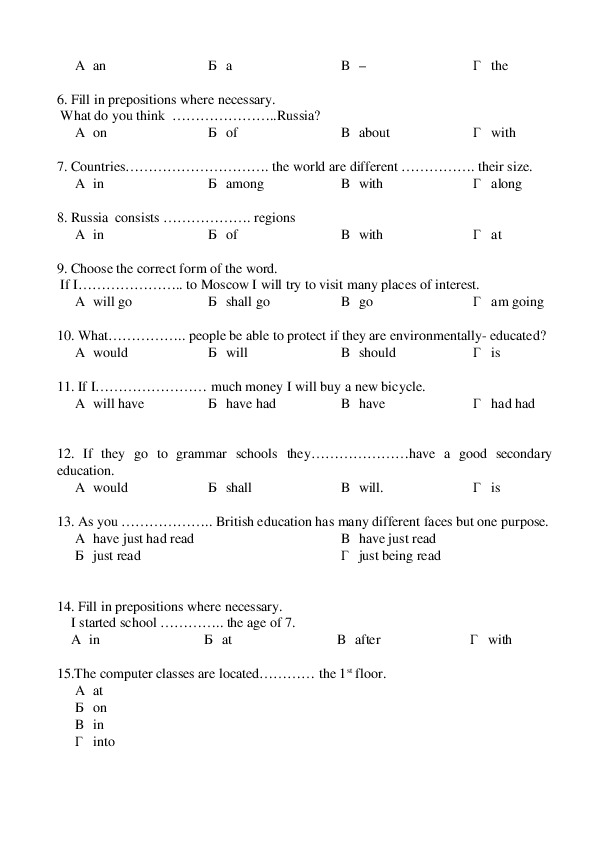
Put the appropriate article where necessary.
1. Russia is………………. largest country in the world.
В –
А an
Б a
2.. Russian is……………… language of our country.
А an
Б a
В –
3. There is ……………….. long border coast line on the Caspian Sea.
А an
Б a
В –
4. Rain is usually falls in…………….. spring and …………… autumn.
А an
Б a
В –
5. There are ……………… few rivers and lakes in Altay.
Г the
Г the
Г the
Г theА an
Б a
В –
Г the
6. Fill in prepositions where necessary.
What do you think …………………..Russia?
А on
Б of
В about
Г with
7. Countries…………………………. the world are different ……………. their size.
А in
Б among
В with
Г along
8. Russia consists ………………. regions
А in
Б of
В with
Г at
9. Choose the correct form of the word.
If I………………….. to Moscow I will try to visit many places of interest.
А will go
Б shall go
В go
Г am going
10. What…………….. people be able to protect if they are environmentally educated?
А would
Б will
В should
Г is
11. If I…………………… much money I will buy a new bicycle.
А will have
Б have had
В have
Г had had
12. If they go to grammar schools they…………………have a good secondary
education.
А would
Б shall
В will.
Г is
13. As you ……………….. British education has many different faces but one purpose.
А have just had read
Б just read
В have just read
Г just being read
14. Fill in prepositions where necessary.
I started school ………….. the age of 7.
А in
Б at
В after
Г with
15.The computer classes are located………… the 1st floor.
А at
Б on
В in
Г intoLESSON 4 «The Republic of Komi»
Task 1: Read the text
THE KOMI REPUBLIC.
The Komi Republic is situated in the European part of Russia. The territory of the republic
is equal to that of several European states put together. The total area is 416,8 thousand sq.
km.
The population is 1 ml 247 thousand people. In the North, it is bounded by the cold Arctic
Ocean, in the East there are the Ural mountains, while in the South and West the K.R. is
bounded by the Kirov, Perm and Archangelsk regions. The climate here is continental with
long and rather severe winter and short cool summer. In the Northern part, the climate is
very severe and relatively mild in the SouthWest. The lowest temperature in winter may
fall to 50° degrees below zero and in summer, it rises to 34° degrees above zero. Winter
lasts for 5 months in the South and in the North it may last even for 7 months.
Two thirds of the Republic are occupied by Parma “ taiga'' in Komi, coniferous forests,
such as pinetrees, firtrees, aspen, birch, rowantree, bird cherry and willow also occur in a
coniferous forest. The second climatic zone is the tundra. In spring wild geese, swans,
ducks and other birds arrive. In summer there are millions of mosquitoes, blackflies and
gadflies. Great collectivefarm herd of reindeer can be met in the vast territory.
The Northern part of the republic lies in the tundra zone with permanently frozen ground.
Vegetation consists mainly of mosses, lichens and marsh weeds.
The territory of the republic is plane. Only the Timan range is stretching through it from
northwest to southeast, its highest point is 465 meters. In the Urals the highest mountain
Narodnaya is, 1895 meters.
The fauna is much similar to that of NorthWestern Europe. There are 20 species of fur
bearing animals: squirrel, hare, fox, bear, marten, wolf & others. Of the large planteating
animals, the elk is most common. There are 200 species of forestbirds. Among them are
black grouse, wood grouse, hazel grouse, ducks, geese, willow grouse. some of them are
resident, the rest are regular visitors of our places.
The rivers in the republic are rich in fish: salmon, omul, Siberia whitefish, sturgeon, sterlet.
The main rivers are the Pechora, the Vychegda, the Mezen, which are navigable in summer
and play an important role in the republic economy.
The Komi Republic is rich in timber and mineral resources, which include all elements of
Mendeleyev’s Periodic table. Coal, oil, natural gas, rock salt and other ores created a highly
developed industry in the Republic. It is difficult to say when man first began to develop
this severe but wonderful land.
1
2
total area – общая территория
stretch – протягиваться3 TIMAN mountain ridge – Тиманский кряж
4
5
6
7
8
9
fir– tree – хвойное дерево
bird–cherry tree – черёмуха
rowan tree – рябина
alder – ольха
birch – берёза
poplar – тополь
10 acacia – акация
11 lilac – сирень
12 give place – уступать место
13 extensive – обширная
14 marshland – болотистая местность
15 severe – суровая
16 relatively mild – относительно мягкий
17 temperature range – температурный диапазон
18 mamma1 –млекопитающее
19 polar fox – песец
20 silver fox – чернобурая лиса
21 marten – куница
22 elk – лось
23 lynx– рысь
24 mammalia – млекопитающие
25 squirrel – белка
26 species – биологический вид
27 black–cock – тетерев
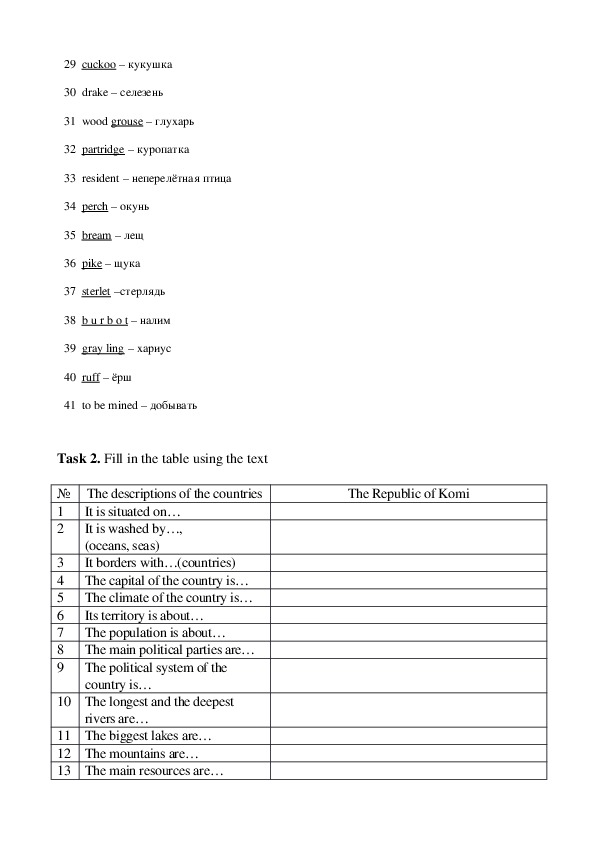
28 hazel hen – рябчик29 cuckoo – кукушка
30 drake – селезень
31 wood grouse – глухарь
32 partridge – куропатка
33 resident – неперелётная птица
34 perch – окунь
35 bream – лещ
36 pike – щука
37 sterlet –стерлядь
38 b u r b o t – налим
39 gray ling – хариус
40 ruff – ёрш
41 to be mined – добывать
Task 2. Fill in the table using the text
№ The descriptions of the countries
1
2
It is situated on…
It is washed by…,
(oceans, seas)
It borders with…(countries)
The capital of the country is…
The climate of the country is…
Its territory is about…
The population is about…
The main political parties are…
The political system of the
country is…
3
4
5
6
7
8
9
10 The longest and the deepest
rivers are…
11 The biggest lakes are…
12 The mountains are…
13 The main resources are…
The Republic of Komi14 The main industries are…
15 The largest cities are…
16 The most famous sightseeing’s
are…
17 The total area of the country
is…
Task 3.
Complete these sentences using the text :
1) The Komi Republic is situated …
2) It borders on …
3) The territory of the Komi Republic …
4) The climate is …..
5) The fauna of the Komi Republic …
6) There are more than 200 species of …
7) Some of them are resident …
8) Our republic is rich in …
9) The chief root crops …
Task 4: Translate the following sentences using the words from the texts.
1 Общая территория республики около 416,8 т. кв. километров.
2 Нет возвышенностей выше, чем 500 метров.
3 Лес покрывает большую часть республики.
4 Хвойные деревья, рябина, черёмуха, тополь, акация, сирень, ольха
характерные деревья для нашей земли.
5 Затем лес уступает место обширной лесотундре и болотам.
6 Климат суровый на севере и относительно мягкий на юге и юго – западе нашей
республики.
7 Температурный диапазон от +1 на юге до – 6 на севере.
8 Около 20 видов крупных млекопитающих лось, куница, песец, чернобурая
лисица, рысь, медведь, волк и т. д.
9 Около 200 видов птиц глухарь, рябчик, тетерев, кукушка, утка и т. д.
10 Реки и озёра полны рыбой щукой, окунём, налимом, хариусом и т. д.Task 5, Agree or disagree Are these sentences true or false? …
1 The total area of the Komi Republic is 416, 8 thousand square kilometers.
2 The Timan mountain ridge runs from the South to the North.
3 The climate of the republic is much milder than that of Russia.
4 The fauna is much similar to that of North Western Europe.
5 Industry doesn’t play an important part in the economy of our republic.
6 The first hunters & fishermen came to our republic in the 5th – 6th centuries &
settled down along the rivers & lakes.
Task 6. Fill in the blanks with prepositions.
by, from …to, to, in, through, of:
1 1. The Komi Republic is situated … the European part of Russia.
2 2. The total area … the republic is 416,8 th. sq. km.
3 3. … the North it is bounded … the Artic Ocean.
4 4. The Timan mountain ridge runs … the South … the North.
5 5. The temperature range is …. +1 … the South …. –6 … the North.
6 6. Oil is exported … many parts of our country … the pipelines Usa – Uhta –
Yaroslavl.
Task 7. Read text and answer questions;
SYKTYVKAR
The first mention of a settlement dates from 1586.Almost two centuries later the
village UstSysola was renamed into the city of UstSysolsk by the Nominal decree of
the Empress Catherine dated January 25, 1780.Thus was appreciated the importance of
UstSysolsk as the centre of the area development.
August 22, 1921 is an important landmark in the history of the city. Komi Autonomous
Oblast was founded at that time and the city obtain the status of the oblast centre. The
present name Syktyvkar received on March 26, 1930 ,when celebrating its 150
anniversary.On the 5th of December 1936 a new constitution of the USSR was adopted, according
to which there was formed the Komi Autonomous Soviet Socialist Republic and
Syktyvkar became the capital of it.
According to the constitution of the Republic of Komi adopted on February 17,1994,
Syktyvkar is the capital of the Republic of Komi, democratic lawful state in a structure
of the Russian Federation.
The city is situated on the northeast of the European part of Russia in 1410 kilometers
from Moscow on the bank of two riversthe Sysola and the Vychegda, and is
surrounded by forests. Its total area 0,7 thousand square kilometers ..
Syktyvkar has a highly developed economic infrastructure, which allows to play a
noticeable role in development of the Republic of Komi.
Syktyvkar’s industrial image is determined by more than 40 large industrial firms.
There are about 230 enterprises all in all.
Dominating branch of industry is timber, woodworking, pulp and paper. This branch
is represented by the most powerful in the European North of Russia JCS"Syktyvkar
Timber industrial complex", JSC Sysolales","Syktyvkar woodworking plant" and
others.
Agroindustrial,mechanical engineering and building branches are highly developed in
Syktyvkar.JSC"State farm Prigorodnyj",State enterprise"Experemental Industrial
Holding specialize in production of vegetables in the open and closed ground, potatoes,
on milkmeat cattle breeding. The food processing industry is represented by enterprises
processing milk, meat, grain and other kinds of commodity.
Syktyvkar is also a large scientific, cultural, educational and sport center of the
Republic. The Komi Scientific Center of the Ural Branch of the Russian Academy of
Science is situated in the city. There are 5 higher educational institutions the
university, pedagogical, forest and medical institutes, Republican Academy of state
service and management. There are also many colleges, secondary vocational schools.
In the city work 147 educational entities, in which more than 60 thousand children and
adolescents are trained and educated. Among them are: the Creativly Palace for
children and youth, nonstate orthodox grammar school,57 secondary schools of general
egucation,12 high and grammar schools, lyceums, the Syktyvkar boys choir. There are
also three municipal entities: the Syktyvkar musical, choreography and art schools, and
specialized sporting school of the Olympics reserve “Youth” for children and teenagers.
Syktyvkar is a cultural center. There is the National museum of the Republic of
Komi,the National Art gallery, State Opera and Ballet Theatre, State Academic Drama
Theatre, National library, 4 cinemas, 18 club entities.
Medical service includes 17 hospitals,38 polyclinics,9 pharmaceuticals entities. Among
them there is a Cardiology center which was opened in 1998 and is recognized to be the
best in the NorthWestern region.The network of social entities is being developed. Among them there is the municipal
"Center of the social help to family and children of Syktyvkar», «House of night stay
for people without the definite habitation and occupation», «Center for teenagers social
rehabilitation».
The population is about 250000 people .It is the city of remarkable people. which have
created a powerful scientific and manufacturing potential, have constructed modern
habitation massifs and industrial firms, high schools, theatres and museums.
Questions:
1.What was the first name of the city?
2.Why is August 22, 1921 an important date in the history of the city?
3.When did the city receive the present Komi name “Syktyvkar”?
4.Where is the city situated?
5.What is its total area?
6.What are dominating branches of industry?
7.What are the names of the biggest enterprises?
8.What is the biggest scientific center in Syktyvkar?
Task 8.
TEST
1 The present name Syktyvkar received on
a. March 26, 1930
b.
March 16, 1930
March 06, 1930
c.
2. A new constitution of the USSR was adopted and Syktyvkar
became the capital of Komi
a. On the 5 th of November 1936
b. On the 5th of October 1936
c. On the 5th of December 1936
3. The Cardiology center was opened
a. 1996
b. 1997
c. 1998
4.
Dominating branch of industry is
a.
b.
c.
timber, woodworking, pulp and paper.
timber, woodworking, shipbuilding
timber, woodworking, textile
5. The city is situated on the bank of two rivers
a. the Sysola and the Vychegda
b. the Sysola and the Mezen6. The total area of the Komi Republic is
c. the Sysola and the Luza
a.516, 8 thousand square kilometers
b. 416, 8 thousand square kilometers
c. 616, 8 thousand square kilometers
7. There are … species of furbearing animals in Komi
a. 10
b. 20
c. 30
8. In the Urals the highest mountain Narodnaya is,
a.1895 meters.
b.1897 metres
c.1899 metres
9. the Timan’s, highest point is
a. 475 metres
b.455 metres
c. 465 metres
10. The Manpupuner rock formations are set of … gigantic
abnormally shaped stone pillars.
a. 5
b. 6
c. 7
11.The total area of Syktyvkar is
a. 0,7 thousand square kilometers
b. 0,8 thousand square kilometers
c. 0,9 thousand square kilometers
12. Who was the founder of Drama theatre?
a. I. Kuratov
b. V. Savin
c. V. Timin
13. In what year was opening of Syktyvkar state University
a. in 1972
b. in 1975
c. in 1978
14. The flag of Komi consists of three colours:
a. blue, green, white
b. blue, red, white
c. blue, grey, white
15. The emblem of Komi is
a. a woman’s face, a bear, elks heads
b. a woman’s face, a wolf, elks heads
c. a woman’s face, a bird, elks headsРекомендуемая литература:
Кубарьков Г.Л Тимощук В.А «Сборник 1000 новых тем современного
английского языка» Ростов на Дону, ООО «Удача»2014г
Голицынский Ю.Б. «Великобритания» Пособие по страноведению, Санкт
Петербург, КАРО, 2012г.
Костина Е.А. «О Соединенных Штатах Америки»: учебное пособие для
студентов. Москва, «Московский лицей». 2010г. Ростов на Дону ООО «Удача»
2014
Бурлак А.И., Дж. Г. Бурлак. «Знакомство с Америкой» Москва, Астрель,
АСТ, 2009г.
Голицынский Ю.Б. «United States America» Пособие по страноведению, Санкт
Петербург.
В.В. Бурлакова «Великобритания. Физическая и экономическая география», М.
Просвещение, 2013.
. «О Британии вкратце». Сост. В.В. Ощепкова, И.И. Шустилова. М. Просвещение,
2012.
. Ф.М. Рожкова «Пояснительные тексты к альбому «По странам изучаемого
языка» под ред. Ю.Ф. Гурьевой». М. Просвещение,2014
И.А. Тенсон, Г.А. Войтова «Обычаи и традиции в Великобритании и Соединенных
Штатах», М. «Международные отношения», 2014.
Сафонова В., Кузьмина Л., Смирнова Е. «Британская литература и культура», М.
2013. г, КАРО, 2012г.
И.П Агабекян Английский для ССузов. – Ростовн/Дону, 2014.
Л.Г. Чичерова Л.Г. Английский на каждый день. – М., 2011.
1 Рогова Г.В. Английский за два года. – М., 2014.
ЭЛЕКТРОННЫЕ ИСТОЧНИКИ ИНФОРМАЦИИ
:// www
. fio
? id =10001125 (Подборка интервью
:// www
. forum
. gov
. uk.
. entertainment
:// www
/ items
. royal
. asp
1. Сайт британской монархии – http
/ center
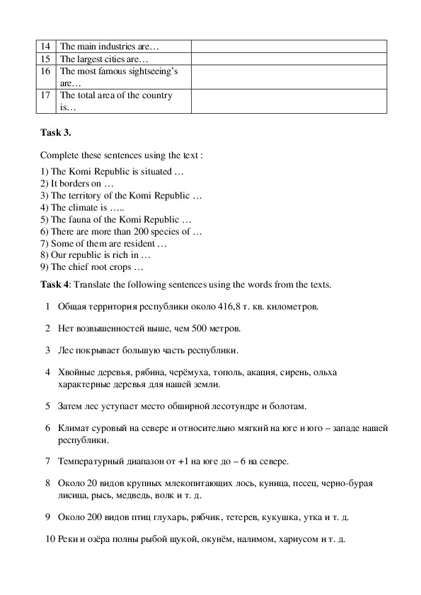
2. Сайт http
. ru ./ som
известных личностей).
3. Сайты http
сверстниками по обсуждению вопросов, которые волнуют молодежь).
4. Сайты http
5. Сайты http
переписки).
http://nsportal.ru/shkola/inostrannyeyazyki/angliiskiiyazyki/library/razrabotka
uroka soedinennyeshtatyameriki
http://festival.1september.ru/articles/527877
:// www
. kidlink
:// www
. stolaf
. org (Участие в проектах).
. iearn
. iecc
. org, http
. org, http
:// www
:// www
/ iecc (Организация
. edu
./ network
. ie, http
:// www
. news
. bbc
. co . uk (Контакт со