Поделиться
|
Long-term plan unit: |
School: |
||||||||||
|
Date: |
Teacher name: |
||||||||||
|
Grade: |
Number present: |
absent: |
|||||||||
|
Theme of the lesson |
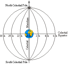
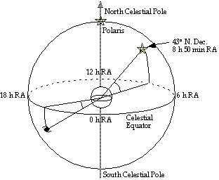
Visible movement of stars at different geographic latitudes |
||||||||||
|
Learning objectives that are achieved at this lesson (Subject Programme reference) |
Use the country names that match the latitude and longitude points to help you solve the riddle. |
||||||||||
|
Lesson objectives |
Students will · identify the difference between latitude and longitude. · find on a world map the location identified by a pair of map coordinates.
|
||||||||||
|
Success criteria |
Students can · identify the difference between latitude and longitude. · find on a world map the location identified by a pair of map coordinates.
|
||||||||||
|
Language objectives |
Are defined for non-language subjects. Keywordslongitude, latitude, equator, meridian, Prime Meridian, geography, map Subject-specific vocabulary & terminology:
Useful sets of phrases for dialogue and writing: The …… is the half of the Earth north of the equator, and the southern ……. is the half south of the equator Instead of 360°, a circle is broken into 24 hours of right ascension
|
||||||||||
|
Values instilled at the lesson |
Specify the values of the Integrated Educational programme as well as national, universal values, which are aimed to be instilled at this lesson. Values are instilled by/through ... (description of activities and / or content). |
||||||||||
|
Cross-curricular links |
Mathematics |
||||||||||
|
ICT skills |
Describe what kind of ICT skills the students will be able to develop at the lesson |
||||||||||
|
Previous learning
|
What have students already learned or what do they need to know before this lesson? (main concepts, facts, formula,theories) How will you activate their previous learning? |
||||||||||
|
Course of the lesson |
|||||||||||
|
Planned stages of the lesson |
Planned activities at the lesson |
Resources |
|||||||||
|
Beginning
|
At the beginning of the lesson it is important to focus on: Grabbing learners’ attention Determining the lesson objectives/LO together with students Determining the "zone of proximal development" of students, expectations by the end of the lesson
|
|
|||||||||
|
Middle
|
|
|
|||||||||
|
End
|
At the end of the lesson, learners reflect on their learning: - What has been learned - What remained unclear - What is necessary to work on Where possible the learners could evaluate their own work as well as the work of their classmates using certain criteria. |
|
|||||||||
|
Differentiation – how do you plan to give more support? How do you plan to challenge the more able learners? |
Assessment – how are you planning to check students’ learning? |
Health and safety regulations |
|||||||||
|
Differentiation can be by task, by outcome, by individual support, by selection of teaching materials and resources taking into account individual abilities of learners (Theory of Multiple Intelligences by Gardner). Differentiation can be used at any stage of the lesson keeping time management in mind.
|
Use this section to record the methods you will use to assess what students have learned during the lesson. |
Health promoting techniques Breaks and physical activities used. Points from Safety rules used at this lesson. |
|||||||||
|
Reflection
Were the lesson objectives/learning objectives realistic? Did all learners achieve the LO? If not, why? Did my planned differentiation work well? Did I stick to timings? What changes did I make from my plan and why?
|
Use the space below to reflect on your lesson. Answer the most relevant questions from the box on the left about your lesson. |
||||||||||
|
|
|||||||||||
|
Summary evaluation
What two things went really well (consider both teaching and learning)? 1:
2:
What two things would have improved the lesson (consider both teaching and learning)? 1:
2:
What have I learned from this lesson about the class or achievements/difficulties of individuals that will inform my next lesson? |
|||||||||||
Скачано с www.znanio.ru
Материалы на данной страницы взяты из открытых источников либо размещены пользователем в соответствии с договором-офертой сайта. Вы можете сообщить о нарушении.